I had a client who had purchased a 1 acre piece of property for $250,000 to build a community center in close proximity to a college campus. The real estate agent had told this client that the property was completely usable except an area at the rear of the property where there was a small stream. It turns out that this small stream drained several square miles upstream of the site, i.e. the stream was not so small.
As I begin to dig into the details of this site, the stream had a buffer associated it, (like most streams in Georgia, that’s where this site is located). However, due to it’s proximity to a water intake downstream, the normal 50-ft buffer requirement was required to be doubled to 100-ft.
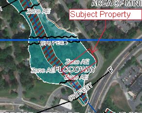
In addition to the buffers, almost the entire property from curb to stream was in the 100-year federally regulated floodplain. See excerpt from FEMA floodplain map below (the flood plain area is in cyan and the approximate parcel area is traced in red).

With some clever landplaning we were able to develop a plan that allowed the construction of the client’s building (albeit on stilts) and a small parking lot utilizing ¼ of an acre of land. This was about all the usable acreage that could be developed and still meet the stringent stream buffer and floodplain requirements.
Net result, about a quarter of the land the client purchased was actually usable. That’s right, the effective cost of the usable land was $1,000,000/acre.
This is not the first time we have seen a similar situation and I’m quite sure it won’t be the last. It is so important to hire a site planning consultant to investigate the restrictions on a piece of property that may not be obvious at first glance BEFORE purchasing the property. :-)


